Oswestry in the Sixties
I was born in Oswestry in the early sixties and left the town in the early eighties. As I attempt to time travel back to the late sixties, memories from over fifty years ago are inevitably vague. Oswestry was known for being on the border between England and Wales. It was located in a rural part of Shropshire, surrounded by countryside, yet quite urban in the centre. Once, a railway town with a significant station and engineering works. The presence of the railways ended in the sixties with the Beeching cuts, and Oswestry had to change.
The sixties were a time of transition with a need for homes for a growing population. In the early sixties, my parents bought a semi–detached bungalow on a new housing estate at the end of Cabin Lane. We lived on a road called Whitefriars. At the bottom of the garden, there was a flimsy hedge. Beyond that hedge, fields, old farm houses and an enchanting world of nature which required serious exploration.
We subsequently moved to a different part of Oswestry. We listen to Sugar, Sugar by The Archies on a portable record player and dance in the garden. Today, the ghosts are the ghosts of memories.
Exploring nature and testing boundaries
At a young age, Dad would sometimes take my sister (Clair) and me down the lanes beyond the hedge, and we would pass the haunted houses. Gunnera grew along the edge of the lanes out of all proportion to us as children. These were happy times. A little older, I explored these fields and lanes beyond my home with friends.
During school holidays, in the daytime, we undertook most of our explorations. Upon reflection, we had no sense of rights of way or legal constraints; we were both fearless and foolish. I know our desire to build dams with mud and stones was dangerous for livestock and annoyed farmers. However, this wasn’t wilful defiance, but rather learning through experimentation. We explored and mentally mapped our local terrain, driven by a playful desire to learn about and engage with our surroundings. The following map draws upon fifty-five-year-old memories. I make no claims to either accuracy or artistry. It is my best effort to suggest the respective locations of the three haunted houses.
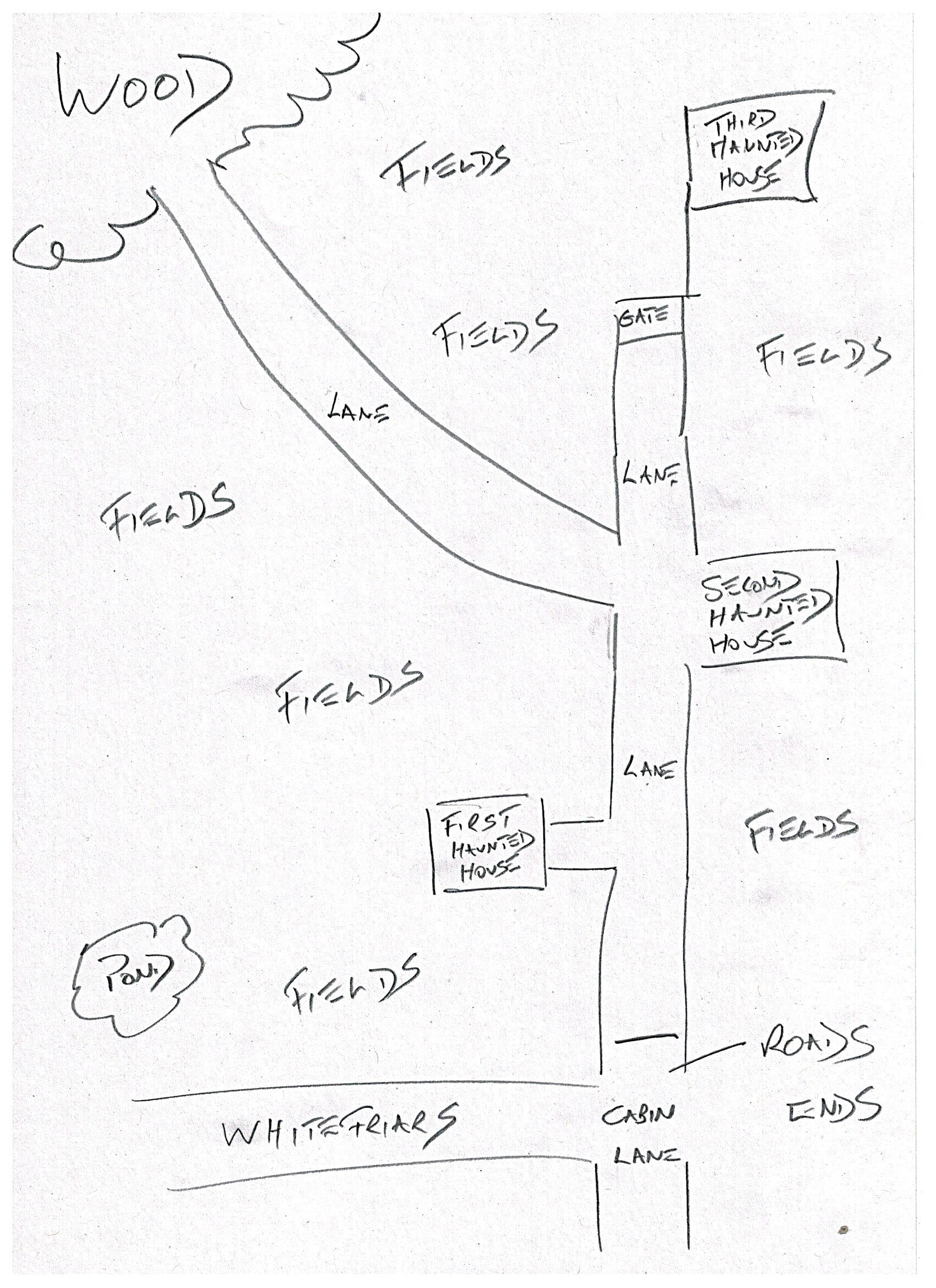
The three Oswestry farmhouses
Whilst the map above was drawn from vague memories, these scanned black and white photographs below are real, if blurred. This was a time before smartphone photography and user-friendly digital photography. My Dad had a Russian camera, which he used with enthusiasm, but the results were frustratingly mixed.

In the first photograph, I am enthusing to my audience (probably Mum, Dad and Clair) about the virtues of the countryside at the bottom of the garden. In the second photograph, the first haunted house is evident in the background. At this age, I was not exploring the haunted houses. However, the view on the horizon would have inevitably caught my imagination.
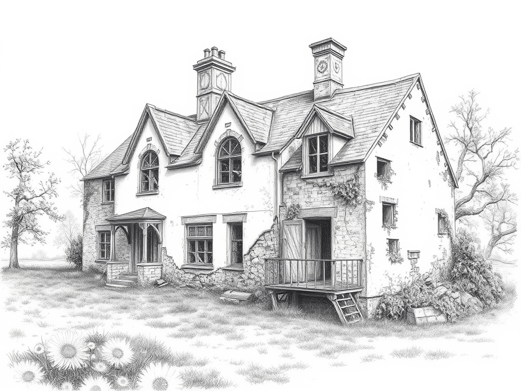
Children passed local terminology from generation to generation. We referred to the three farm houses as the first, second and third haunted houses. The farm houses were relatively close together, each no more than a mile apart (see earlier map). However, each house was a bit further away from the relative safety of the housing estate. So, for us, the first, second and third labels denoted moving further from home and safety. The stone-built farmhouses were quite substantial buildings. They suggested more small-scale farming than today.
I have no memory of the health and safety signage you see attached to derelict buildings these days. However, the first and third haunted houses were physically difficult to access. Pragmatically, the second haunted house was the most accessible. It had a large courtyard, making for easy access, and you could move between rooms quite freely (though illegally).
Usefully, there was a huge horse chestnut tree close to the courtyard. This tree had been repeatedly coppiced, probably due to its proximity to the building. Severe coppicing had resulted in the upward growth of a huge main trunk, stopping at about six to ten feet. Subsequently, branches had grown, forming a goblet shape. Generations before us had hammered large nails into the tree trunk, providing foot and handholds to climb the tree.
As children, we would gather by climbing up onto the goblet-shaped natural platform. This was HQ, where we would plan the day’s adventures. I do remember once having a serious fall from this tree, thankfully, nothing was broken. My bones seemed less brittle back then. We all affectionately referred to this horse chestnut tree as either Stumpy or Baldy, I think it was the latter.
Paranormal investigations (yesterday)
As a seven or eight-year-old child, I decided to visit the second haunted house to catch a ghost. Oddly, this investigation into the paranormal was a solo effort, separate from my young explorer friends. Subsequently, these investigations were regularly recalled at family gatherings. At least I was a paranormal pioneer, well before the television paranormal investigations.
It is often said that children are more receptive to spirits, ghosts and otherworldly occurrences. I was certainly convinced that I was going to catch a ghost. This may have been the overactive imagination of youth. Practically, though, what would I do with the ghost once caught?
My paranormal apparatus was equally intriguing. Two lengths of wood, each about three to four feet long, were connected with a piece of string approximately six feet long. The cunning plan was to throw the outstretched string over the ghost, enabling me to pull the ghost towards me. As I type, the child-like naivete is apparent, similar to a child innocently petting a dangerous animal. In my case, the mission appears to have been to befriend a ghost. Though, how would I look after and care for this ghost?
Whilst the efficacy of my equipment and housing the ghost was highly questionable, there was a bigger problem. My exploration curfew was teatime, with bed after that. It meant capturing a ghost in the daytime – not ideal. Each day, I told my Mum what I was doing and would return to her in the late afternoon, disheartened at my failure to catch a ghost. After a few days, I had to admit defeat and give up on my quest.
Historical investigations (today)
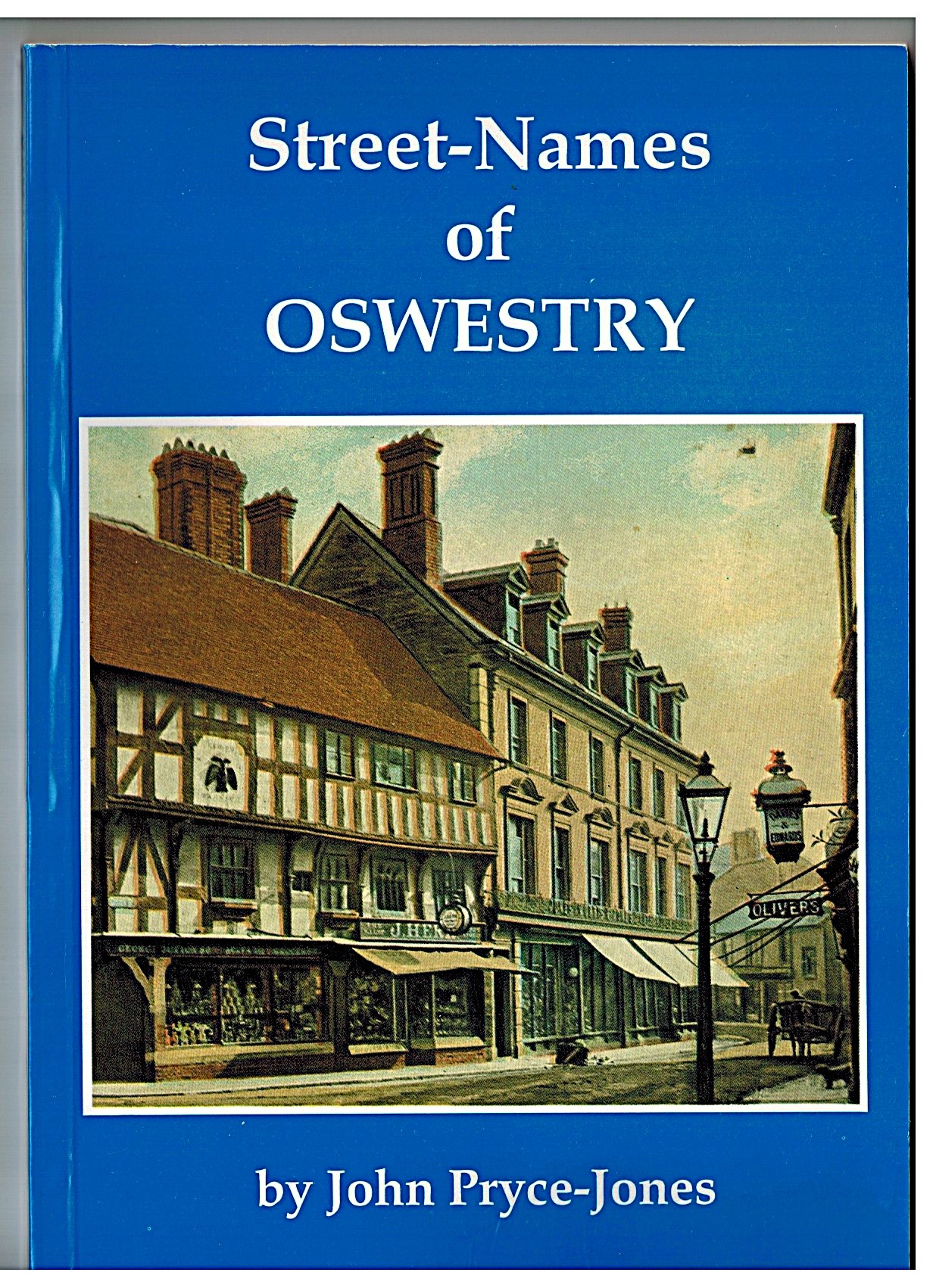
It was good to reminisce, but older and a little wiser, I am curious to learn more about the history of the local terrain featured here. I delve into Oswestry history books, belonging to my now sadly deceased Mum and Dad (Sheila and Derek). Most illuminating is Street Names of Oswestry by John Pryce-Jones, which features Cabin Lane. I think Dad used to play table tennis with John Pryce-Jones, but I need to stay focused.
Cabin Lane ended at Burgesses Moor and Lousy Moor. Lousy Moor frustratingly doesn’t yield to internet searching. However, the search engine artificial intelligence suggests, potentially boggy land, problematic for farming, which sounds very plausible. Certainly, we encountered boggy fields on our explorations, not helped by our desire to dam every stream in sight. I also have a vague memory that some of the land had been used for landfill before building the bungalows in the sixties, which would have been “lousy”.
Cabin Lane was the tarmacked road leading to Whitefriars and many other roads in this part of Oswestry. Beyond Whitefriars, Cabin Lane wasn’t tarmacked. It continued as a simple and beautiful traditional soil lane, providing access to the three haunted houses with hedgerows on either side. The existence of a Cabin Lane certainly can be traced back five centuries. Unable to offer a definitive rationale for the derivation of the Cabin Lane name, John Pryce-Jones suggests it may have been as simple as referring to the existence of a cabin or shelter at one point.
Focusing on Cabin Lane as a nearby location is useful in engaging with old maps. I wanted to compare my memory map (see earlier) with more accurate, published old maps. The most accessible free site I found was the National Library of Scotland. I respect the copyright, so I will not copy the map. However, it allowed me to view and magnify Cabin Lane on a 1900 map. You may be able to access the map HERE, alternatively, search on their site for Oswestry, Cabin Lane.
On the 1900 map, the second haunted house appears to be the main farm, with the other two haunted houses depicted as far smaller satellites, possibly homes for labourers or tenant farmers. On the 1900 map, Cabin Lane ended at the third haunted house. The map depicts a lane branching off near the second haunted house, woodland and a pond. Reassuringly, the 1900 map fitted with my memories of the late sixties.
Today, the farm houses and fields no longer exist. Hopefully, the ghosts were respectfully rehoused; we will never know. The landscape I once enthusiastically explored was inevitably developed. Pragmatically, there was a need for homes in the sixties, and there is a similar need today.
It is fitting that an extended Cabin Lane is now the central thoroughfare through the new housing development. Cabin Lane served the three farms when they were in operation, as well as centuries earlier. Everything else changed, but Cabin Lane remains a story of a bygone era hidden in plain sight.
Updates
If anyone has any further information/photographs about the three haunted houses, please do let me know, and I will update this post. The Contact page generates an email to me. Alternatively, I have enabled comments on this post, though the spam filters, beyond my control, can be too enthusiastic!
